Jieyi Tan
 M.E., Wuhan University (2025)
My name is Jieyi Tan(谭杰议), I’m currently a master's student at the School of Remote Sensing and Information Engineering, Wuhan University, under the supervision of Prof. Yansheng Li. My research interests focus on Spatio-Temporal Foundation Model and its applications in Geoscience  and Human Health
  .
.


Education
-
Wuhan University
M.E. in Photogrammetry and Remote Sensing Sep. 2025 - Jun. 2028 (Expected)
-
Wuhan University
B.E. in Remote Sensing Science and Technology Sep. 2021 - Jun. 2025
Honors & Awards
- Outstanding Undergraduate of Wuhan University 2025
- Outstanding Bachelor's Thesis of Wuhan University 2025
- Zheng Geru Scholarship (First Prize) 2024
- IEEE GRSS Data Fusion Contest (2nd Place) 2024
- Surveying and Mapping Science and Technology Paper Contest (Grand Prize) 2024
- SuperMap Cup College GIS Competition (Second Prize) 2023
- Excellent Student Scholarship of Wuhan University (First Prize) 2022
- Merit Student of Wuhan University 2022 & 2023 & 2024
Experience
-
Class 2311, School of Remote Sensing and Information Engineering
Assistant Head Teacher Sep. 2023 - Jun. 2025
-
Class 2105, School of Remote Sensing and Information Engineering
Monitor Sep. 2021 - Jun. 2025
News
Selected Publications
(view all ) 
Towards Privacy-preserved Pre-training of Remote Sensing Foundation Models with Federated Mutual-guidance Learning
Jieyi Tan*, Chengwei Zhang*, Bo Dang, Yansheng Li†(* equal contribution)(† corresponding author)
ICCV 2025 ConferenceCCF-A
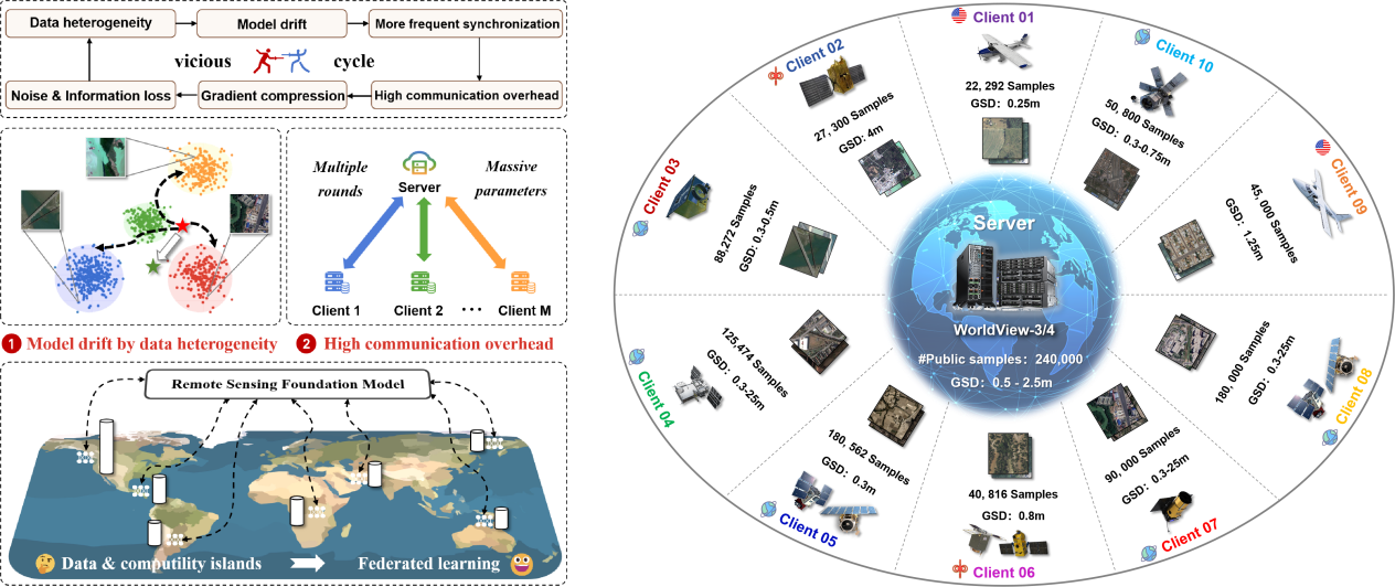
Traditional Remote Sensing Foundation models (RSFMs) are pre-trained with a data-centralized paradigm, through self-supervision on large-scale curated remote sensing data. For each institution, however, pre-training RSFMs with limited data in a standalone manner may lead to suboptimal performance, while aggregating remote sensing data from multiple institutions for centralized pre-training raises privacy concerns. Seeking for collaboration is a promising solution to resolve this dilemma, where multiple institutions can collaboratively train RSFMs without sharing private data. In this paper, we propose a novel privacy-preserved pre-training framework (FedSense), which enables multiple institutions to collaboratively train RSFMs without sharing private data. However, it is a non-trivial task hindered by a vicious cycle, which results from model drift by remote sensing data heterogeneity and high communication overhead. To break this vicious cycle, we introduce Federated Mutual-guidance Learning. Specifically, we propose a Server-to-Clients Guidance (SCG) mechanism to guide clients updates towards global-flatness optimal solutions. Additionally, we propose a Clients-to-Server Guidance (CSG) mechanism to inject local knowledge into the server by low-bit communication. Extensive experiments on four downstream tasks demonstrate the effectiveness of our FedSense in both full-precision and communication-reduced scenarios, showcasing remarkable communication efficiency and performance gains.
Unleashing the Potential of Remote Sensing Foundation Models via Bridging Data and Computility Islands
Yansheng Li, Jieyi Tan†, Bo Dang, Mang Ye, Sergey A. Bartalev, Stanislav Shinkarenko, Linlin Wang, Yingying Zhang, Lixiang Ru, Xin Guo, Liangqi Yuan, Lei Yu, Jingdong Chen, Ming Yang†, José Marcato Junior, Yongjun Zhang†(† corresponding author)
The Innovation 2025 中科院一区 Top (IF: 33.2)
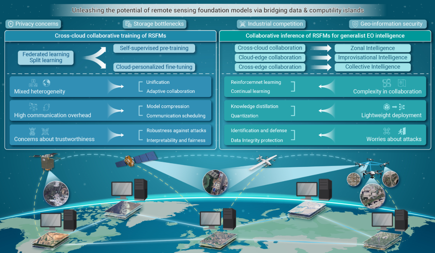
Recently, RSFMs have demonstrated significant potential in advancing generalist earth observation (EO) intelligence. However, the persistent challenges of data and computility islands severely restrict the full potential of RSFMs. Therefore, we strongly advocate for global collaboration among institutions to construct and develop RSFMs through cross-cloud, cloud-edge, and cross-edge collaboration, thereby establishing a collaborative architecture to bridge these islands. Future research should focus on developing collaborative architectures at both hardware and software levels to ensure seamless integration. Ultimately, collaborative approaches will enhance the scalability and efficiency of RSFMs, fostering deeper insights and understanding in EO research and unleashing the potential of RSFMs for generalist EO intelligence.
Domain Knowledge-Aware Remote Sensing Foundation Model for Flood Detection in Multi-Spectral Imagery
Yansheng Li, Bo Dang†, Fanyi Wei, Jieyi Tan, Yangjie Lin(† corresponding author)
IGARSS 2024 Conference2nd Place of 2024 IEEE GRSS Data Fusion Contest
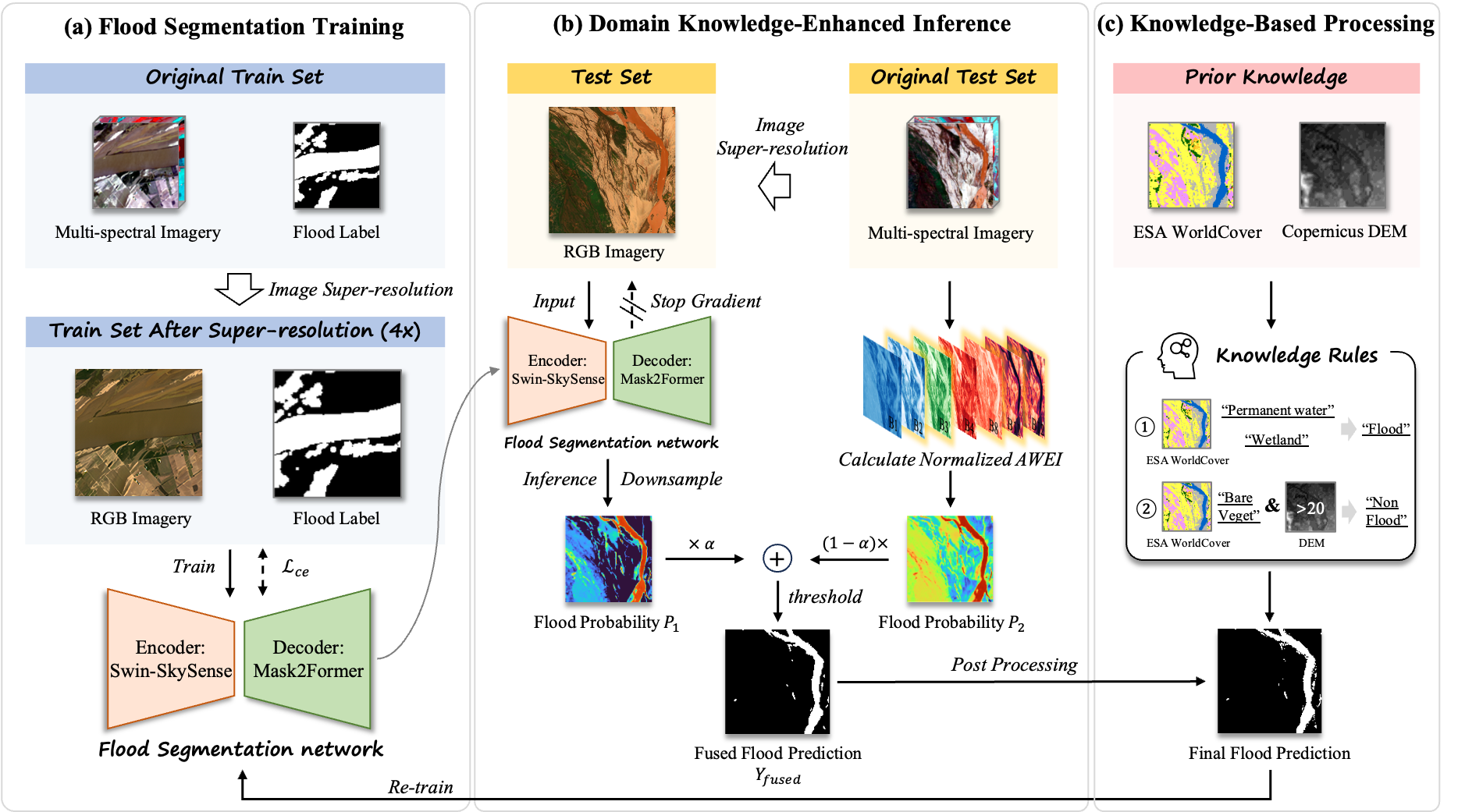
Obtaining accurate and timely flood information is crucial for effective disaster management and response. To address the limitations of existing methods in terms of accuracy and model robustness, this research significantly improves the accuracy and stability of flood detection by integrating domain knowledge into the Remote Sensing Foundation Model (RSFM). Specifically, we employ advanced RSFM to focus on extracting spatial texture features from images after super-resolution. The Automatic Water Extraction Index (AWEI) is introduced to leverage spectral information from multi-spectral imagery, while model fusion techniques further enhance the accuracy of segmentation results. Moreover, we incorporate prior knowledge such as land use products and Digital Elevation Models (DEM) for knowledge rules-driven post-processing, refining the final flood detection results. Experimental results demonstrate that our approach achieve the second-place ranking in the 2024 IEEE GRSS Data Fusion Contest (DFC) Track 2 test phase (F1: 88.25%), highlighting the effectiveness and competitiveness of our method.
Bridging Data Islands: Geographic Heterogeneity-Aware Federated Learning for Collaborative Remote Sensing Semantic Segmentation
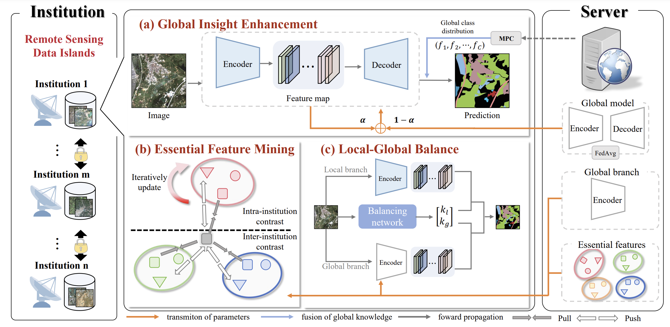
Jieyi Tan, Yansheng Li†, Sergey A. Bartalev, Shinkarenko Stanislav, Bo Dang, Yongjun Zhang, Liangqi Yuan, Wei Chen(† corresponding author)
arXiv 2024 2024年全国大学生测绘学科创新创业智能大赛(科技论文竞赛) 特等奖
Remote sensing semantic segmentation (RSS) is an essential technology in earth observation missions. Due to concerns over geographic information security, data privacy, storage bottleneck and industry competition, high-quality annotated remote sensing images are often isolated and distributed across institutions. The issue of remote sensing data islands poses challenges for fully utilizing isolated datasets to train a global model. Federated learning (FL), a privacy-preserving distributed collaborative learning technology, offers a potential solution to leverage isolated remote sensing data. Typically, remote sensing images from different institutions exhibit significant geographic heterogeneity, characterized by coupled class-distribution heterogeneity and object-appearance heterogeneity. However, existing FL methods lack consideration of them, leading to a decline in the performance of the global model when FL is directly applied to RSS. We propose a novel Geographic heterogeneity-aware Federated learning (GeoFed) framework to bridge data islands in RSS. Our framework consists of three modules, including the Global Insight Enhancement (GIE) module, the Essential Feature Mining (EFM) module and the Local-Global Balance (LoGo) module. Through the GIE module, class distribution heterogeneity is alleviated by introducing a prior global class distribution vector. We design an EFM module to alleviate object appearance heterogeneity by constructing essential features. Furthermore, the LoGo module enables the model to possess both global generalization capability and local adaptation. Extensive experiments on three public datasets (i.e., FedFBP, FedCASID, FedInria) demonstrate that our GeoFed framework consistently outperforms the current state-of-the-art methods.